Archives for category: photographs

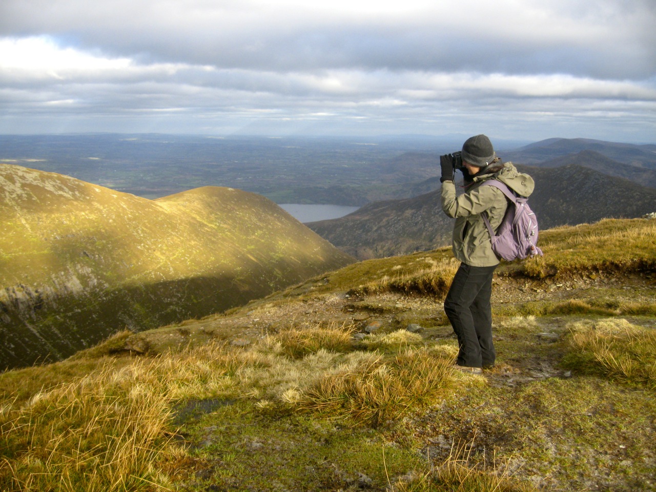
On the day after Christmas Day, I climbed Carrauntoohil, the highest mountain in Ireland.

Carrauntoohill

Carrauntoohil is located in Co. Kerry, not so far from the towns of Killarney and Killorglin. It is part of the Magilicuddy Reeks, the loftiest of the mountain ranges in Southwest Ireland.

To reach Carrauntoohil, you must first negotiate your way through the Hag’s Glen, a massive U-shaped valley strewn with ancient moraine. The most usual route to the top is via the Devil’s Ladder, a steep and now quite dangerous route.

Hag's Glen

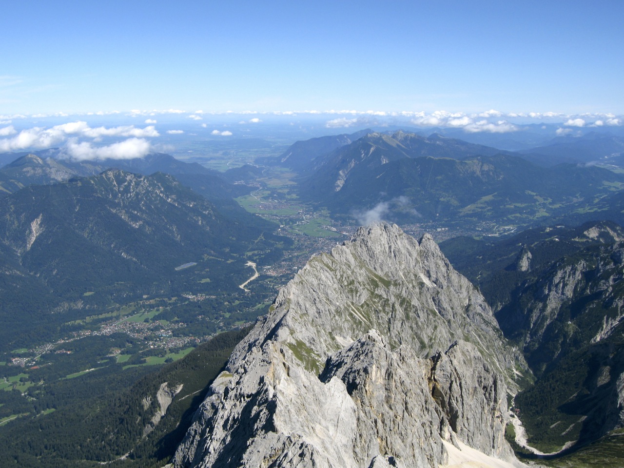
We didn’t go that way. Instead we ascended via the far more impressive Shay’s Gully route. On the way up, you can see ahead of you the clear remnant of an ancient glacier now long disappeared.

Ascending Shay's Gully

It was a long slog, but we reached the mountain peak in good time. It was like a train station at the top! St. Stephen’s Day – what we in Ireland call the day after Christmas Day – is an incredibly popular day for mountain climbing. Literally hundreds of people take the journey, and there have been more than one casualty on this day, on this mountain, in the past.

At the top

It was absolutely freezing at the top, so we didn’t stay for too long. We descended via Heaven’s Gate: a steep yet manageable and highly picturesque natural stairway to the bottom of the valley.

Descending via Heaven's Gate

I took this picture of a sheep on the way down. And you think you’ve got troubles..

Sheep on cliff

A big thanks to Barry who lead us up and back down again. He was a great help to us particularly where we needed to negotiate steep rock walls on our way down.

add to del.icio.us : Add to Blinkslist : add to furl : Digg it : add to ma.gnolia : Stumble It! : add to simpy : seed the vine : : : TailRank : post to facebook

I spent yesterday out of the office, exploring one of the most beautiful and delightful cities on the planet. San Francisco is twinned with Cork, and there are some similarities: the proximity to the ocean, the steep hills, the relaxed lifestyle and ambience. Both are cities for living in as opposed to just working in. Of course, San Francisco is so much more: the weather is superb, the complexity, size and diversity of the place is orders of magnitude greater and then in the distance is this enormous feat of engineering- the Golden Gate Bridge. (Actually there are other suspension bridges linking San Fran to the other side of the Bay, but they don’t get a look in). 

Just click on any of these photos for a bigger picture.

San Francisco morning

First on our itinerary was Chinatown. As you walk down through this sizeable district, you quickly begin to forget that you are in the same country as strip malls and banal chain restaurants. It’s a whole world in miniature.  

sf4-chinatown

Then on to Broadway, the Italian district and in the distance the Transamerica Pyramid. We visited a museum of the Beatnik culture, where I picked up “On the Road” by Jack Kerouac.  

sf5-transamerica

From here we headed up past the twists of Lambert St and looked out east over the city. The Coit tower is one of San Fran’s famous landmarks. 

sf7-coit-tower

Then on down to Fisherman’s Wharf to look at the Golden Gate for the first time. There’s Alcatraz in the distance. 

sf7-powell

After a nice relaxing meal we visited Pier 39 to do some sea lion watching and to make a visit to Rodney Lough’s photo gallery. After seeing some of the photos I am seriously considering hanging up my camera in shame. This guy is good.

sf10-pier-39

Then out bicycle trip to the Golden Gate. Cripes. Where do you begin? So many photo opportunities, so little time! If you ever get a chance to visit San Fran, take a bike ride to the Bridge. You won’t regret it and it’s really good value for money.

sf13-golden-gate

Another photo..

sf15-golden-gate

And just one more, taken as the mist was invading the Bay from the Pacific Ocean.

sf17-golden-gate-fog

add to del.icio.us : Digg it : Stumble It! : : post to facebook

Rainbows. My one abiding memory of my holiday in Kerry this year.

We stayed in Banna Strand, a few miles outside Tralee. There is a marvelously long  beach there, plus a swimming pool and kids’ activity centre so the kids could be entertained whatever the weather. 

That’s not to say we couldn’t travel: there is so much to see in Kerry, it would be a pity to stay in one place all the time. We headed out to Ballybunnion, Dingle, Slea Head, Castlegregory, Killarney, Glencar, Crag Cave, and Fenit Harbour among many other places. All these places may be just names to you, but they are all spectacularly beautiful, especially when the clouds are changing the lighting so often. 

This is the town of Dingle, or to be correct An Daingean – the government changed its name to its Irish form a few years ago resulting in widespread uproar. All over Kerry the name “Dingle” has been erased from roadsigns with white sticking tape..

A seagull by Slea Head, overlooking the Blasket Islands. 

This guy is Brendan the Navigator, a Kerryman reputed to have travelled to Newfoundland and Iceland back in the middle ages.  

This is the Gap of Dunloe: a deep glacial valley beside the Magillicuddy Reeks (Ireland’s highest peaks). The whole Killarney area is Ireland’s equivalent of the Lake District. 

This is Ballybunnion on a freezing, stormy day.

The last ones, I promise. I’m sending them up because I had a camera at just the right time when I was passing by Lime Street Station yesterday evening.

That’s St. Georges Hall in the foreground, and if you look carefully, you will see a second arc just above the main rainbow. 

Cool, huh?

The city is a quite a building site at the moment. It might have something to do with being the European City of Culture this year.. Seriously though, if Cork 2005 is anything to go by, it will look really swell in 2 years time.  

The city is dripping with history. There are many fantastic 19th Century buildings throughout the city centre. I was particularly taken by the Pumphouse on my way into the Liverpool Maritime Museum.

I managed to go on a fantastic walk up the Nire Valley in west Waterford this Sunday. While most people were enjoying a relatively dry morning, we decided to seek a place of near constant rain and mist. 

The walk took us from the car park over an improvised bridge and up into the mountains via a long gentle ridge on the western side of the valley. Once we reached the Comeragh plateau, we passed down a boggy valley leading (unexpectedly) to the top of the Mahon Falls. From there we headed towards The Gap and back to the car park. All in all, the walk lasted 6 hours.  

The heather is in full bloom at the moment. Pictured against the deep greens of a wet Irish summer it’s nothing short of spectacular. 

And now, a bonus: a quick time-lapse video featuring some pretty nifty high-speed sheep..

The videos are up. If any of you would like a better quality DVD (with photos and extra video footage) of the whole thing, send me an email.

Day 1

Day 2

Day 3

Sunday brought us from Kenmare to Killarney along the old road, a distance of around 18km. It took us through some of the best scenery that Ireland has to offer.

The terrain was excellent for long distance walking. Gravel paths, railway sleepers and flagstones kept our tormented feet well away from the worst of the boggy land.

The path is very interesting. Trees emerge from the bog in unusual places, abandoned homesteads dating back to the time of the famine are common, and we walked through a narrow glen in one place that seemed to come right from the movie “Darby O’Gill and the Little People”.

After a number of hours we descended the steps by Torc Waterfall. Only a few minutes to go. Or so I thought. We still had Muckross Estate to get through.

And finally, the Brehon Hotel, the finish line, and a chance to take off our boots at long last..

Update: Video of Day 3


Maybe we’ll see you on the 2009 walk?

Saturday brought out the crowds. Over 200 people gathered together in Sneem for the walk to Kenmare. 

This walk was the longest of the lot – 28km (19 miles). It’s around 42,000 footsteps and our boots reminded us of this fact with each footfall. The walk was relatively flat, with long stretches on tarmac mingled with a good deal of woodland walking. 

After what seemed like an endless forced march, we ended up in Pat Spillane’s Pub for a quick pint. It could have all ended there…

… but no. We had a few more hills to climb…

… and donkeys to annoy.

Update: Here’s the video of Day 2

It’s over. My feet are sore, but the experience was terrific.

This is the a quick report on the first day of the walk.

Day 1 took us from Caherdaniel to Sneem, a distance of 18km. Around 150 people participated. We walked through a variety of different landscapes: from woodland to mountain bog. The pace was fast, with few breaks in between. 

One of the big treats of the day was coffee and scones in a house that was open to all the walkers. It happened about an hour into the walk though, so it lulled us into a false sense of security! The next few hours were conducted at a fast pace, with few breaks in between.

The last part of the trip was mainly flat and along small country roads. It was a race to the finish. Sneem was about to host it’s annual Wife Carrying Competition: if only our team could have taken part..


Update: Here’s the video for Day 1. (3m)